GEOD
input
Specifying another input scale with the input command
The input command is used to enter coordinates in another system of units.
To draw a cross-section from a geological map, the best method is to scan a strip along the section line and display it directly in the working window with an image command. It then becomes possible to position precisely the outcrops of faults and bed boundaries.
If no scanned version of the map is available, one must return to the older method: taking a strip of paper, fixing an origin, marking the positions of formation boundaries and faults with a pencil, measuring them with a ruler, and finally entering these measurements into the GEOD script window.
This work may be tedious, because the measured positions in millimetres or centimetres on the sheet of paper must be converted into x coordinates expressed in metres.
This is why GEOD provides a command called input, which automatically converts these values.
The command follows this syntax:
input e
where e is the denominator of the map scale.
For example, if one works with a 1:50,000 map, one writes:
input 50000
After this, the positions measured directly in millimetres on the map may be entered.
For example, if four elevation points with altitudes 500, 450, 600, and 400 have been identified on a map, located respectively 10, 14, 18, and 30 mm from the origin, one may write:
  line
      10 500
      14 450
      18 600
      30 400
The x values, here 10, 14, 18, and 30 in millimetres, are then automatically converted by GEOD into geographic coordinates, namely 500, 700, 900, and 1500 metres.
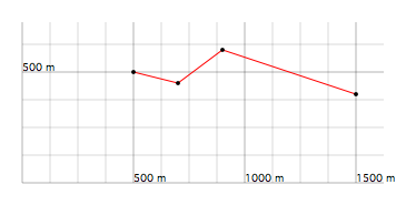
Figure 1 : Topographic profile constructed with the help of an input 50000 instruction.